Orkney - Archaeological Sites
Skara Brae - Ring of Brodgar - Stones of Stenness
Maes Howe - Brough of Birsay
Rennibister Earth House - Broch of Gurness
Onstan cairn
A few others are given on my main Orkney page
These are just some of the ancient places that can be found on Mainland Orkney:
PREHISTORIC VILLAGE OF SKARA BRAE
Admission charge.
Built before the Pyramids, Stonehenge and the Great Wall of China, the ten houses that can be seen today were occupied from about 3100 to 2500 BC. Historians believe that the site was gradually abandoned as the island's community developed and people's needs changed. Over the centuries it was covered with sand and remained untouched until a winter storm blew up in 1850, thus bringing the Stone Age into the modern era.
It sits just above the magnificent white beach of the Bay of Skaill that arcs round in one huge semicircle. Since their original roofs of turf have long since disappeared, visitors can now look down into the mound and see the layout of the village. The main "street", a semisubterranean passage linking the houses, runs down the middle of the site from today's entrance to what is thought to be a workshop at the other end where tools would have been made.
|
Each house has its hearth in the centre and box beds around the walls. Bracken or heather would have been used for bed linen and animal skins for quilts to keep out the cold. In some there are seats, grinding stones and boxes on the floor. Possessions were either hidden in alcoves in the walls or displayed on shelves on the dresser which faces the entrance of most houses. Larger cells in the inner walls, under which primitive drains were found during excavations, may have been used as toilets. Local man Sigurd Towrie has detailed information about the site. |
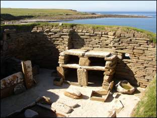 Skara Brae photo 2004 copyright The Internet Guide to Scotland |
If you'd like to read all about it and see lots of colour photos, check out the 48-page paperback guide by the Arnolds produced in May 1997: Stone Age Farmers Beside the Sea: Scotland's Prehistoric Village of Skara Brae.
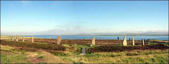
Ring of Brodgar photo copyright 2004 The Internet Guide to ScotlandRING OF BRODGAR
This stone circle has been dated to at least 1560 BC. Even though today only thirty-six stones remain out of the original sixty, the size of the site is breathtaking. Set on a promontory between the Lochs of Harray and Stenness, the circle is exactly 125 Megalithic yards across (just over 100 metres). Around it runs a ditch some three metres deep which alone would have taken 80,000 man-hours to dig. The stones themselves were somehow brought from a quarry situated to the north of Skara Brae and carefully erected at six degree intervals. The openness of the Ring's location would have made it an ideal setting for a lunar observatory if that was indeed its role. Several burial mounds exist in the immediate vicinity, but the centre of the circle has never been excavated.
Local man Sigurd Towrie has detailed information on all this.
Robert Pollock has also written about this circle.
|
STONES OF STENNESS Less than a mile from the Ring of Brodgar is this earlier circle. Few of the original twelve stones are still intact and upright, two having been damaged by a farmer in the last century and others having simply disappeared. Laying on the ground in the centre, four small stones have been set in a square. When excavated, human remains were found to have been cremated there. |
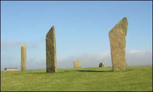 Stones of Stenness photo copyright 2004 The Internet Guide to Scotland |
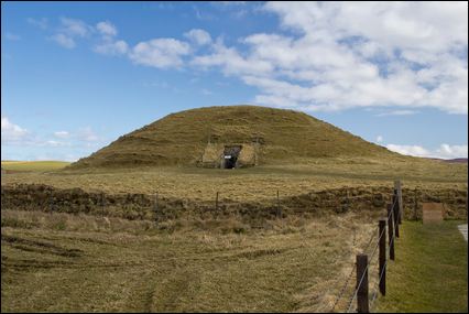
MAES HOWE
Admission charge.
Accessed via a field of cattle, this, the best example of a chambered tomb to have been found anywhere in north-west Europe, appears as a large green hump on the landscape. A wide ditch circles the mound to form an enclosure over a hundred metres across.
|
The custodian takes small groups of visitors inside. A low passageway runs some 16 metres into the middle of the mound. Halfway along in a recess on the left is a blocking stone thought to have been used to seal the tomb from the inside when rituals were taking place. At this point the roof and side walls were constructed using massive slabs weighing up to 30 tonnes. From there, the passage expands a little and slopes upwards into darkness where you can at last stand upright. When I was there, the custodian activated several dim lights and we realised that we had emerged through one of the walls of a square chamber. Part way up each of the other walls was the entrance to a small cell. These 3 individual tombs would probably have been blocked up by the huge stones found lying on the ground in front of the openings. When the sun sets near the winter solstice, it shines directly through the passageway and onto the rear wall of the main chamber. |
 Maes Howe © johnbraid | Fotolia.com |
In modern times Maes Howe wasn't successfully investigated until 1861 when someone managed to get in through the roof which had long since collapsed. Only the remains of a human skull and some horse bones were found. It is believed that the Vikings plundered the tomb in the mid-twelfth century and carted off whatever had been lying there for the previous 4000 years. In compensation, they left behind a series of inscriptions which amounts to the biggest collection of runic writing in the world.
Mysteriously, several of the runes talk of treasure being carried away by Hakon, whilst others speak as though it is still hidden in the mound and to the north-west. However, most of their writings are frighteningly similar to the graffiti we see in our streets and playgrounds today. In the Norse equivalent of "I woz 'ere", one set of squiggles proudly proclaims "Haermund Hardaxe carved these runes". Tryggr, Arnfithr and Ottarfila all recorded their visits in the same juvenile manner, but another scribe obviously thought himself too famous to bother with his name. "These runes were carved by the man most skilled in runes in the Western Ocean" he brags. Someone else, with an equal show of imagination, tried to carve the sixteen-character runic alphabet but unfortunately managed to get the last two wrong. Then right across the wall of the south-east side chamber next to an extremely bizarre drawing of what researchers have described as a slobbering dog stretches "Ingigerth is the most beautiful of women", under which is written "Benedikt made this cross". Whether or not they were there together remains another matter of conjecture.
Viking carvings located on the side of a tall slab that forms part of one of the corner buttresses represent a lion (which looks more like a dragon), a walrus (which could in fact be an otter with a fish in its mouth) and a most peculiar snake (which appears to have tied itself in a knot). Another pillar bears primitive lines and triangles which, through their similarity to ones found at Skara Brae, are likely to have been etched by the builders of the tomb.
Local man Sigurd Towrie has detailed information on all this.
Robert Pollock has also written about this monument.BROUGH OF BIRSAY
Driving through Birsay village, you pass the 16th-century mansion of Robert Stewart whose son built the Earl's Palace in Kirkwall. Park on the coast and follow the path. The Brough is situated on a small island which can only be reached at low tide plus or minus two hours. Once over the concrete path which leads through the sand and rocks, you find yourself amongst a jumble of ruins from Pictish, Early Christian and Viking settlements.
Enclosed within a large square wall, lie the remains of a 12th-century church and cemetery which may have been built over an earlier ecclesiastical site established by the Celts. A Pictish symbol stone was discovered in this graveyard. With the original in an Edinburgh museum, a copy now stands in its place, showing three bearded warriors, an eagle and a fantasy beast known as the swimming elephant.
Around the church are the remains of other buildings which have proved harder to identify. Birsay is said to have been the seat of Earl Thorfinn the Mighty and some of what can be seen today could be what is left of his palace. Archaeologists though are in no doubt as to the significance of the foundations found up on the grassy slope. Long ago, they were Norse hall-houses.
Broch of Birsay © David Lloyd | Dreamstime.comRENNIBISTER EARTH HOUSE
A two-thousand year old souterrain whose purpose remains unknown. Located on a farm four miles outside Kirkwall. Enclosed by iron railings in the middle of the farmyard is a sort of manhole cover which lifts to reveal an almost vertical metal ladder disappearing down into the darkness. Bring a torch! Below in the oval chamber is where the jumbled bones of six adults and twelve children were discovered in 1926 when a tractor fell through the roof. The original means of entry was probably the narrow passage which leads off one side of the chamber. It is not thought to have been built as a burial vault and yet after its initial function was fulfilled, it appears to have become the resting place either of those who used it or those who came after them.
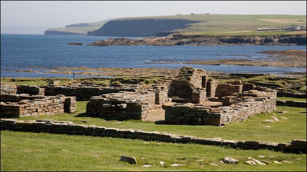
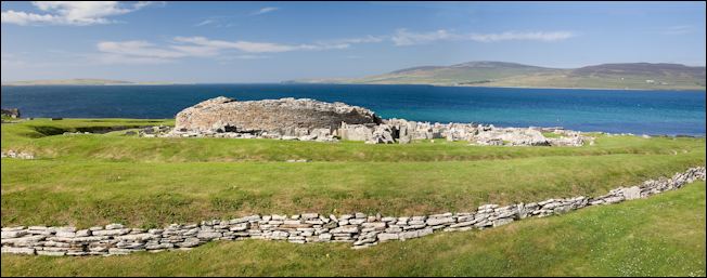
BROCH OF GURNESS
Admission charge.
Broch of Gurness © David Lloyd | Dreamstime.com
|
The remains of a central round tower dominate the promontory and directly overlook the island of Rousay opposite. Built in the first century BC, it may have stood up to 12 metres high and had 3 lines of ditch and rampart defences. Around it were dwellings, some now destroyed by the ever encroaching sea, but many of whose stone skeletons are still visible just above ground level. Finds of Norse and Pictish artefacts indicate ten centuries of almost continuous occupation. Historic Environment Scotland now owns the site and has opened a small exhibition which is included in the cost of admission. |
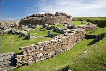 Broch of Gurness © David Lloyd | Dreamstime.com |
ONSTAN CAIRN
Follow a muddy track towards what appears to be a grassy bump on the landscape and you will find this cairn which dates from around 2500 BC. After crouching down to pass through a low, narrow passage, you enter a rectangular chamber. At either end, upright stone slabs make screens behind which human remains were found in 1884. Runic letters and a bird are carved on the lintel of an opening in the side wall which gives access to a small cell where two crouched skeletons were discovered. Since most of the original roof was lost in centuries gone by, a modern structure had to be built within the earth mound. A hole provides a reasonable amount of daylight, but doesn't detract from the sensation of entering a tomb. During excavations, finds were also made of pottery whose distinctive style has become known as Unstan ware.

Suggested reading
If you are sightseeing around the islands, then an indispensable tool is the Leisure and Tourist Map for Orkney and Shetland which pinpoints well over 100 important places to see and has a gazetteer with a short description of each.

|
Orkney
Lovely colour guide with over 100 pages of photos devoted to these amazing islands. Covers local heritage and culture, ancient monuments, history of settlement, nature and the landscape, places to visit, etc. Second edition published 2007. Even if you don't get chance to buy it before you go, you will certainly want a copy for a souvenir when you have visited! Order online from Amazon.co.uk (commission link) Another useful one of the Pevensey island guide series covers Shetland. |

|
Monuments of Orkney: A Visitor's Guide (Explore Scottish Monuments)
Published in 2012. In this extensively illustrated guide, Orkney-based archaeologist Caroline Wickham-Jones introduces more than 60 monuments in concise and accessible terms, set in context by a brief history of the islands. A site location directory is also included. Amazon US - Amazon UK (commission links) |

|
Orkney: A Historical Guide Paperback
Published in 2015. Caroline Wickham-Jones, whow has worked extensively on Orcadian sites for many years, introduces the history of the islands and provides a detailed survey of the principal places and sites of historic interest. Amazon US - Amazon UK (commission links) |

|
Orkney
Written by well-known archaeologist, Anna Ritchie, this 163-page book is part of the excellent Exploring Scotland's Heritage series and is well worth having if you want all the details on the ancient monuments here. Amazon UK (commission link) |

|
The Islands of Orkney
Lovely hardcover book containing over 300 pages written by Liv Kjorsvik Schei with photographs by Gunnie Moberg. Amazon UK |

|
Stone Age Farmers Beside the Sea:
Scotland's Prehistoric Village of Skara Brae Lots of colour photos and a well-written text explaining what is known about this most unique archaeological site on mainland Orkney and the people who lived there. Makes history come alive! Amazon US - Amazon UK - Kindle edition - UK (commission links) |

|
Historic Environment Scotland: Ancient Shetland
128-page paperback book written by Val Turner. Amazon US - Amazon UK (commission links) |
|
A Guide to the Stone Circles of Britain, Ireland and Brittany
Comprehensive guide produced by famous expert Aubrey Burl. With maps, photos, descriptions, practical information on how to find them and what condition they are in, this is a very useful handbook for visiting prehistoric sites. Amazon US - Amazon UK (commission links) |
![]()
Links
The Internet Guide to Scotland
Kirkwall - Orkney
The official Orkney Tourist Board web site
Orkneyjar - excellent online guide and photos by local man Sigurd Towrie
Orknet (another interesting site)
Wildabout Orkney History Tours
Charles Tait - local professional photographer
Stones of Scotland by Paola Arosio and Diego Meozzi
Orkneylinks.co.uk
Orkney Genealogy & Orkney Family Names