Standing stones and ancient monuments in Scotland
Here is just a selection of some historic sites in the Scottish Highlands and Islands including the famous Callanish.
|
ISLE OF ARRAN
|
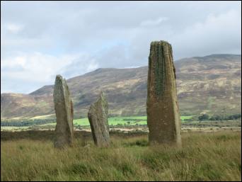 Photo copyright The Internet Guide to Scotland |
ISLE OF ISLAY
Robert Pollock has produced an excellent guide covering the stone circle 6km north of Portnahaven (in the SW of the island). He also has a guide with diagrams covering the standing stone just outside Port Ellen (on the SE coast of the island) and another one close to the town at Kilbride.The site of Finlaggan located near Port Askaig is also worth a visit. It's an archaeological dig around what was the ancient seat of the Lord of the Isles in the 14th and 15th centuries. There are 2 islands on this site - Eilean Mor (Big Isle) and Eilean na Comhairle (Council Isle). On the so-called Big Isle there are two main ruins (a chapel dedicated to Saint Finlaggan and a service building), plus the remains of over 20 buildings one of which was a great hall. Carved gravestones were found near the chapel. Robert Pollock has a guide with diagrams covering a standing stone at Finlaggan near the Visitors' Centre.
Ten crannogs (ancient loch dwellings) on Islay have been surveyed by Mark Holley.
ISLE OF JURA
There are several standing stones scattered about the east coast of Jura. A Neolithic burial cairn can be found south of Strone farm. South-east of Ardmenish, on Lowlandman's Bay is the dun known as An Dunan.KILMARTIN
Some 30 miles south of Oban, the area around Kilmartin is rich in history. Around the village many prehistoric and medieval monuments can be found including burial cairns, stone circles and cup-and-ring engravings. An interactive map of all the local archaeological sites is provided on the Kilmartin House web site.ISLE OF MULL
Robert Pollock describes the standing stones south of Tobermory. Before you reach Dervaig along the road from Tobermory, if you have a good map of the area, you might like to explore some of the nearby standing stones. You will see a couple marked on the map to the left of this road, then closer to the village are the Kilmore standing stones located just inside the forest on the right. From there you can go deeper into the forest and after around half a mile you will see another clearing containing yet more stones by Maol Mor. Robert Pollock has produced a guide with diagrams covering some of these stones. Further on near Calgary (13 miles west of Tobermory), there's the Cillchriosd standing stone.At Ardura you can take a track down to Lochbuie, home of the MacLaines and site of Moy Castle and a Bronze Age stone circle. Robert Pollock has produced an excellent guide with diagrams covering the stone circle and also a standing stone.
Nine crannogs (ancient loch dwellings) on Mull have been surveyed by Mark Holley.
ISLE OF COLL
Archaeological sites on Coll include a cairn at Arinagour, a souterrain at the Arnabost crossroads and Iron Age forts such as the ones at Dun an Achaidh and Feall Bay. Two standing stones can be found in the west at Totronald. These are called Na Sgeulachan in Gaelic ('teller of tales' in English) and may have been used for astronomical purposes or they could have belonged to a temple. A dozen crannogs (ancient loch dwellings) have been surveyed by Mark Holley.ISLE OF TIREE
Four crannogs (ancient loch dwellings) on Tiree have been surveyed by Mark Holley. There are also several interesting archaeological remains on the island including a 30 foot-diameter broch at Vaul Bay, with walls 12 feet thick and, in the west at Kilkenneth, the ruins of Chapel of Saint Kenneth, one of Saint Columba's followers.ISLE OF SKYE
On the lochside at Kensaleyre on the NW coast of the Trotternish peninsula are some prehistoric stones whose origin is a mystery. Legend says that there were once 3 stones which were used to support cauldrons of venison stew for the Fiennes (mystical giants who threw stones).ISLE OF BARRA
Standing stones at Borve. Dun Bharpa is a large well-preserved Neolithic chambered burial cairn 2.5 km south of the road between Craigston and Grean (map grid reference NF 671019). Before the turn to Grean and Cleit, on a low hill close to the road, are the well-preserved remains of an Iron Age broch called Dun Chuidhir or Cuier (map grid reference NF 664034).ISLE OF SOUTH UIST
About halfway down South Uist, you will see a turn to Bornish (Bornais in Gaelic). Dun Bhulan (on a spur of land overlooking the beach) is an Iron Age broch and settlement (map grid reference NF 714297). There's also a track south from Bornish leading to a standing stone. On the southern coast of the island, a standing stone can be seen close to the shore near the Pollachar Inn.ISLE OF NORTH UIST
There are many sites of historical interest scattered about North Uist. Some are near roads, others are harder to reach. Check with the Tourist Office when you get there to make sure of access.
Between Clachan and Lochmaddy is the Barpa Langass Neolithic cairn which has an intact burial chamber. The monument is some 25 metres in diameter and 4 metres high. It is about 150 metres south of the road. One kilometre south-east of here (or 100 metres from the end of the track at Langass Lodge) are the remains of a stone circle, Pobull Fhinn.
Near Carinish are the ruins of a 13th century church (Teampull na Trionaid), thought to have been founded by the daughter of the warrior Somerled. It is signposted 200 metres from the raod at Carinish (Cairinis in Gaelic). A long cairn, dun and stone circle can all be found east of here. Photos and description on my North Uist page.
Several monuments can be found along the road to the Harris/Berneray ferry point at Newtonferry (Port nan Long in Gaelic). About 3 miles north of Lochmaddy, climb Blashaval hill to the left of the road and you will find 3 standing stones known as the Three False Men or Na Fir Bhreige. Legend has it that these mark the graves of spies who were buried alive. You'll find them on the western slope of the hill.
Another mile or two further up on the right-hand side of the road on an islet (with causeway) in Loch an Duin stands the broch known as Dun Thorcuill (or Torcuil) (map reference NF 888 737).
Just before you reach Newtonferry is Loch an Sticir. There on an islet (with causeway) is a broch known as Dun an Sticir which has a late medieval hall (map reference NF 897776). Photos and description on my North Uist page.
In the west of the island, take the track from Tigharry to the summit of South Clettraval (133 metres high). Here you will find a Neolithic chambered cairn of the 'Clyde' type, unique in the Western Isles, and also an Iron Age wheelhouse (map reference NF 749713). Link to my photos.
Further south on the hill called Unival (or Uneabhal in Gaelic) is a Neolithic chambered cairn and late Iron Age cellular house (map reference NF 800668). Uphill walk east-south-east of the so-called Committee Road.
Photos on my North Uist page.ISLE OF HARRIS
The road from Northton in southern Harris arches round alongside three-mile long Scarista beach - one of many stretches of golden sand you will see on the west coast of the island. From the road you can see the remains of a standing stone arrangement (map grid reference NG 021939) - check out the guide by Robert Pollock.After passing lots of deserted beaches all the way up the west coast, you might care to stop at this one, Traigh Iar (or Nisabost) just before you reach Horgabost. A sign points the way to Macleod's standing stone on the far side of the sand about 700 metres from the road. The stone is quite large and it's well worth the walk if only for the view you have of the island of Taransay. Robert Pollock has details and diagrams.
Situated in a private garden, the MacDonalds' B&B at number 6 Horgabost, is a Neolithic chambered burial cairn of which only the central setting remains. It is clearly visible from the main road at the junction with the road to Glen Horgabost (map grid reference NG 047966).
ISLE OF LEWIS
On top of Gallows Hill in the grounds of Lews Castle in Stornoway there's a chambered cairn which has been partly obscured by a modern cairn (map reference NB417323).Take the A866 east of Stornoway and explore the Eye Peninsula, a spur of land which juts out into the Minch. 750 metres south of Garrabost is a chambered cairn (map reference NB 534330). South of there can be found a standing stone and yet further south Dun Bayble. Driving towards Tiumpan Head you will pass Loch an Duin which has a causeway over to an island dun (map reference NB 516304).
Driving down the west coast of Lewis, after you have passed the whalebone arch in Bragar, continue south along the road. Shortly you will see the South Bragar dun in a loch 80 metres east of the road. It can be accessed on foot by a causeway.
|
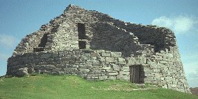
Further south is the famous Carloway broch (15 miles from Stornoway) an Iron Age round fortification some nine metres high in places. It's a short climb up the craggy hillside to the remains of the dry stone tower with its double walls and tiny entrance. As you enter the broch, look for the cavity on the right. It is thought that this was a guard cell where someone would have sat ready to pounce on any unwanted visitors. Once inside the broch itself, you can investigate some of the other cavities and see the staircase and ledge. You get a good view of the surrounding hills and the of the sea. No admission charge. Toilets available. There is a small visitor centre (open April to September, 10am to 5pm). |
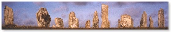
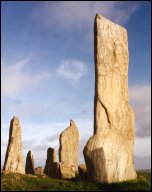
| Dating back over 4000 years, the Callanish standing stones rank second in terms of importance only to Stonehenge. On a headland overlooking part of a huge sea loch, 53 pale grey stones of Lewisian gneiss stand in a curious cruciform. Link to my photos. The heart is a central circle of 13 tall stones where excavations in the mid-19th century uncovered a chambered tomb reported to have contained human remains. From there four limbs run out in line with the cardinal points of the compass. Pointing northwards lie two parallel rows of stones which form an avenue of unknown significance. |
|
Together with eleven smaller sites scattered over the surrounding moorland, the main circle (my photos) seems to have been an ancient astronomical observatory. Detailed calculations have shown alignments with the sun and moon at various times of the year which could have been used to predict eclipses and the coming of the seasons. Curiously, it appears to be situated just south of a sort of lunar "arctic circle" inside which the moon fails to rise above the horizon when it reaches its 19-yearly southern maximum. Robert Pollock has a very detailed guide concerning many of these sites.
There are two other stone circles which you can access near the main site. They are quite easily seen from the main road (A858) just south of the turn to the visitor centre. Cnoc Ceann (Callanish II) is 400 metres from the road (map reference NB 222326). Cnoc Fhillibhir Bheag (Callanish III) is 200 metres from Callanish II along a footpath. I have several photos.
Also visit the Callanish photos on the Stones of Scotland site by Paola Arosio and Diego Meozzi.Opened in June 1995, the excellent Calanais visitor centre includes an exhibition, a gift shop, toilets and a tearoom. The centre is open from 10am - 6pm Monday to Saturday in summer (April to September) and from 10am to 4pm Wednesday to Saturday in winter (October to March). Entry to the centre is free, but there is a small charge for admission to the exhibition. Tel: 01851 621422.
Don't forget that at the other end of the stones is another tearoom which has been here for years in one of the traditional Lewis black houses. Now that the visitor centre has opened, this little place is probably losing customers which is a pity. The standing stones themselves are always open (no entrance fee).
As for other archaeological sites on Lewis, there are lots! There are several sites of interest in the north of the island if you take the A857 heading north of Barvas. At 6 metres high, Clach an Truseil (map reference NB 375538) is the tallest standing stone in Scotland. It is located to the west of the A857 near the village of Baile an Truseil - check out Robert Pollock's guide. Near here is the site of the last battle between the Macaulays and the Morrisons.
Just up the road, 850 metres along a track south-east of Siadar at map reference NB 396541 is what is thought to be a chambered cairn overlain by the foundations of a hall (3000 - 1500 BC). The site overlooks an island dun in Loch an Duin.
Head up to Ness and the Butt of Lewis (the northernmost tip of the island). Dun Mara is an Iron Age fort on a promontory 1.5 miles north-west of Cros (map reference NB 495631). St. Moluag's Church which may date from early 16th century and was restored in 1912 is 100 metres along a footpath north of the B8014 road (map reference NB 519652).
If you drive to Tolsta at the end of the B895 north of Stornoway, you will reach a nice beach. At map reference NB 537496 there is a late prehistoric/medieval dun (Caisteal a' Mhorair) on a rock stack. Take the track leading north to the waterfall. Walk another kilometre north and you will see a fort (Dun Othail) and possible chapel on another rock stack (map reference NB 542514).
There are a couple of archaeological sites to be visited from the A859 between Tarbert (Isle of Harris) and Stornoway. About halfway along this road between Arivruach and Balallan, a small road leads east to the remains of a stone circle which has been partly incorporated into a dwelling of the Laird of Seaforth. This site is located on the shore of Loch Seaforth 500 metres along a track from the road (map reference NB 278166).
The B8060 also branches off the main Tarbert to Stornoway road. After 8 or 9 miles, there's a left turn towards Cromore. You will pass the ruins of Dun Cromore. A track to the left leads you to a causeway from Crowbeg to the island where you can visit Saint Columba's Church (depending on the tides). Map reference NB 385210.
|
ISLE OF GREAT BERNERA
Just off the coast of Lewis, this little island is a lovely gem of a place. There are some of the Callanish group of stones just above the bridge, Dun Bharabhat and a restored Norse Mill. At the far end of the island, an Iron Age village has been discovered by a beautiful beach. A replica house has been constructed. |
INVERNESS AREA
Situated in Glen Urquhart (8 miles west of Drumnadrochit) is the Corrimony chambered cairn surrounded by a circle of 11 standing stones. Robert Pollock has a guide to this site.
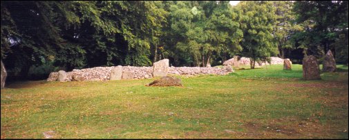
Six miles east of Inverness are the Clava Cairns (also known as Balnuaran of Clava). These Bronze Age chambered cairns are each surrounded by a stone circle in a wooded field. A most unusual place. Robert Pollock has a guide to this site. Photos online by Phil Wright and Undiscovered Scotland.
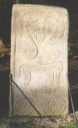
| In the grounds of Brodie Castle there is a Pictish stone which was found in 1781 during excavations for a local church. It was moved here around 1840 and is sculptured with Ogham inscriptions including fish monsters and an elephant. This cross-slab of grey sandstone is known as Rodney's Stone with varying stories as to the origin of the name. Photo reproduced by kind permission of Paul Warrener. |
|
ABERDEENSHIRE
One of the richest areas for standing stones and ancient monuments - so much so that they have created a 'Stone Circle Trail' (in addition to the Castle & Whisky Trails). Check out the official guide by Aberdeenshire council.CAITHNESS
Take the little road inland just north of Lybster on the east coast (some 15 miles south of Wick) and after 5 miles you will reach the Grey Cairns of Camster. You will have to crawl if you want to get inside these chambers which are 5000 years old. North of the village is the Hill O' Many Stanes which features rows of early Bronze Age stones.. Further up the A9 road at Ulbster is the Cairn of Get which is 24m long and 14m wide. Robert Pollock has a guide to standing stones in North and North-East Scotland.ORKNEY
These islands of the north-east tip of Scotland are particularly rich in ancient history, with standing stones, prehistoric tombs and such like. I have a separate file covering Orcadian archaeology.
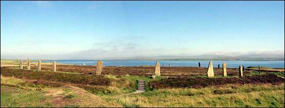
Ring of Brodgar photo copyright The Internet Guide to Scotland
For Scottish travel info, see my tips file or check out the destination highlights.
Customised Self Drive Tours are available.
For more on the Stones of Scotland visit the site by Paola Arosio and Diego Meozzi.
Based in Edinburgh, Jackie Queally of Celtic Trails / Earthwise offers unique personalised tours from Edinburgh to sites of prehistoric, Celtic and medieval/Templar interest, including Rosslyn Chapel and other sacred sites.
Read all about Scottish brochs on George Maciver's web site and blog. www.celtictrailsholidays.co.uk/walking-holidays-in/scotland/
![]()

|
In Search of Ancient Scotland,
A Guide for The Independent Traveler Produced by Gerald and Dorothy Ruzicki, this paperback contains over 350 pages Published in March 2000. Available from Amazon.com (commission link)
|
